We stopped by Sarah J’s in Haines to pick up breakfast sandwiches and coffee before heading off for our 3rd destination on the Circle Route: Haines Junction. We were in no hurry, and anticipated making several stops at various pullouts along the 240 km route.
The skies were overcast, and there were brief periods of light rain – conditions which I normally don’t mind when undertaking a road trip in familiar territory – but we would not be passing through this area again, and I had hoped for better weather conditions.

Salmon trap on the Chilkat River
The Haines Highway follows the Chilkat River on its way out of Haines, and eventually passes through the Chilkat Bald Eagle Preserve. Although the concentrations of bald eagles would not be arriving for another few months, we did spot a few eagles from the turnouts, and appreciated this opportunity to see their feeding and nesting grounds along the alluvial flats of the Chilkat River.
We approached the border crossing at Pleasant Camp, British Columbia with the usual level of nervousness. We were well within our duty limits, but I always dread the experience anyway. After a few simple questions, the Customs officer closed off with “welcome home” – a phrase that struck a chord, and made us happy to be coming home.
Despite the fog patches, we saw glimpses of spectacular scenery along the Haines Highway. We would be back in the area 2 days later to participate in a river rafting trip on the Tatshenshini River, and I vowed to retrace a substantial portion of the highway if the weather and our energy levels permitted. They did, and you can see the images taken on our second trip down the Haines Highway here.
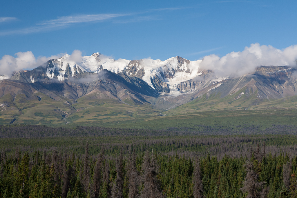
St. Elias Mountains, Kluane National Park
Our first full day in the Haines Junction area allowed us to visit Kluane (“clue – aw – knee“) National Park. After checking in with the park staff at the visitor centre, we proceeded to the trailhead for the Sheep Creek Trail. The staff reminded us to be bear aware while we were out on the trail, but a couple of posted signs that we saw near the trailhead were disconcerting – the first boldly warned of the presence of a bear in the area, while the second was a commemorative plaque in memory of a female hiker who was killed by a bear in 1996 – all in all not such a great way to start a hike!
This trail is rated as moderately difficult and involves a 1,400′ elevation gain as it follows and climbs the contours of Sheep Mountain and represents a 10km round trip. Conditions were hot and dry on this day, so we stopped regularly for water and snacks along the way. We enjoyed beautiful views of Sheep Creek and the Slims River during our outing. We closed out the afternoon with a break by the shore of Kluane Lake, taking in views of the lake, and Sheep Mountain in the distance.
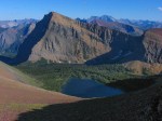
Our second full day in the area promised to be one filled with adventure for we would be taking a day long rafting trip down the Tatshenshini (“Tat”) River with Tatshenshini Expediting. We found the meeting spot, quite literally in the middle of nowhere, and were quickly donning wetsuits and attending a safety talk before heading off. The route follows the Blanchard River until it joins the Tat. With it being later in the rafting season, the rivers offered rapids in the class I to class III range. Our course meandered through an endless series of turns through several ravines – the scenery was simply stunning. We were eventually joined by a couple of eagles who would fly ahead to a distant tree along the banks of the river until we caught up to them, and then repeat the process all over again. Our guides informed, entertained and ensured we had a safe day.
Our third day would be a travel day back toward Whitehorse to finally close the loop on our Golden Circle Route, but not before visiting the Da Ku Cultural Centre in Haines Junction. This beautiful facility is owned by the Champagne and Aishihik First Nations, and offers opportunities to learn about their art, and their history in the region. We engaged one of the staff members in conversation, and we were rewarded with the story of the migration routes of her ancestors as we walked around a very large scale map of the region on the floor. We also made a stop at the Canyon Creek bridge, and visited a First Nations cemetery on the hilltop overlooking the Aishihik River.
You can read more about our journey along the Golden Circle Route here.
This gallery showcases the sites that we observed while in and around Haines Junction, Yukon:


We look forward to your comments...